| Preview | Issue Date | Title | Other title | Author(s) |
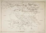 | 1886-01-01 | Compiled from sketch plan supplied by Chas. Chewings Esqr | - | Goyder, G. W. (George Woodroffe) 1826-1898; Crawford, Frazer S. (Frazer Smith) -1890; South Australia. Surveyor-General's Office | |
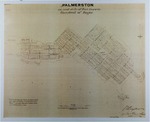 | 1870 | Enlarged plans of Northern Territory townships | Palmerston on east side of Port Darwin, Hundred of Bagot; Township of Southport on the Blackmore, Hundred of Cavenagh, 18 m. S.S.E of Fort Point | Berry, Edwin S; Crawford, Frazer S; South Australia. Surveyor-General's Office | |
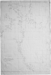
| 1872 | General plan showing natural features of the country, towns, reserves, roads & sectional lands at, and in the vicinity of Port Darwin, Northern Territory of South Australia | - | South Australia. Surveyor-General's Office | |
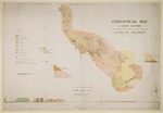 | 1886 | Geological map & sketch sections to accompany the Revd. J.E. Tenison-Woods' report on the geology of the Northern Territory | - | Crawford, Frazer S; South Australia. Surveyor-General's Office | |
 | 1873 | Map of route travelled and discoveries made by the South Australian Government central and western exploring expedition under command of William Christie Gosse : showing natural features and description of country | - | Gosse, W. C.; Berry, Edwin S; Vaughan, Alfred; South Australia. Surveyor-General's Office | |
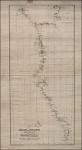
 | 1874 | Map of the country west of the telegraph line in the interior of Australia explored by Mr E. Giles | - | Crawford, Frazer S; Goyder, G. W.; South Australia. Surveyor-General's Office | |
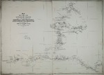
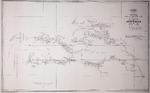
 | 1868-07 | Map of the Northern Territory shewing recent surveys | - | Finnis, Boyle Travers; Hutchison, J; Crawford, F. S.; Cadell, Francis; South Australia. Surveyor-General's Office | |
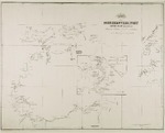
 | 1873 | Plan shewing the Adelaide and Port Darwin telegraph line | Adelaide and Port Darwin telegraph line | Giles, Ernest, 1835-1897; Crawford, Frazer S. (Frazer Smith), d. 1890; South Australia. Surveyor-General's Office | |
 | - | South Australia. Plan of Northern Territory annexed to South Australia : lying to the north of latitude 26° and between longitudes 129� and 138� east, showing routes of exploration, &c., &c. | Plan of Northern Territory annexed to South Australia | South Australia. Surveyor-General's Office | |
 | 1988 | Stuart : new Alice Springs Northern Territory | - | South Australia. Surveyor-General's Office | |